| ||||||
THE RAILROAD
BUILT ON
STILTS
Camas Prairies'
Second
Subdivision
My interest in railbiking came about through a lifelong passion for railroading, so when Dick asked me to join him for a ride on the Camas Prairies' Second Subdivision I jumped at the opportunity. The Second Subdivision had ceased operation and bids have been let for salvage, scheduled for sometime in the Spring 2001. Even though it was in the dead of winter with snow predicted and daytime highs in the 20s, this was a trip not to be missed.
The Camas Prairie Railroad is little known outside the small area it serves, and it is both unusual and spectacular out of all proportion to its obscurity. The original four subdivisions traverse a variety of terrain not equalled in the compass of many railroads ten times its
size. It began as a joint operation between the Northern Pacific and Union Pacific Railroads and for many years owned no rolling stock of its own, but used a stable of obsolete steam locomotives from both railroads providing a veritable museum of motive power.
The headquarters of the Camas Prairie is at historic Lewiston, oldest incorporated town in Idaho, the metropolis of the Idaho Panhandle. Lewiston lies in a spot of scenic splendor at the confluence of the mighty Snake and Clearwater Rivers and is named for the explorer who, with his companion Clark, were the first white men to witness this imposing land. From its modest yard and engine house in East Lewiston,
the Camas Prairie extended four tentacles in the rough shape of a three-pronged spear.
The Third Subdivision, forming the handle of the spear, follows the cavernous undulation of the Snake River Canyon for 72 miles west to Riparia, Washington. The other three branches, comprising the prongs of the trident, fan out to the east from Lewiston, each serving a different type of countryside.
The First Subdivision, central line of the trident, is a river bottom line like the Third. Its entire 76 mile course to Stites, Idaho, lies deep in the crevice of the Clearwater Canyon, never straying more than a few hundred feet from the rushing waters. For several miles east from Lewiston, the canyon is broad and open, its rolling ramparts coarsley serrated by eroded gullies and dotted with little farms. Farther
upstream the canyon gradually closes in upon the river and its walls become more precipitous, occasionally forcing the railroad to tunnel through solid rock butresses rising directly from the waters edge.
The Fourth Subdivision is a remote piece of railroad, sending its trackage deep into the fringe of America's primeval wilderness. Leaving the First Subdiviwion at Orofino, the Fourth immediately loses itself in the isolated fissures of Orofino Creek, wandering back and forth across the stream for 25 miles. At Pierce, remnant of the old gold rush days, the line heads north to thread between the trunks of taller and finer yellow pines and fir. Cresting the Orofino watershed at Summit, the line corkscrews down a two percent grade and finally switchbacks into a secluded vale in the deep forest at its terminus at the old logging camp of Headquarters.
At Spaulding, ten miles east of Lewiston, the Second Subdivision cuts southeastward. The Second is probably the best part of the railroad, making its abandonment an even greater loss. For those of you who will never get a chance to see it, there are some great trestle shots in the movie "Breakheart Pass" starring Charles Bronson. The trestle where the fireman falls to his death is the famous Half Moon (see photo above) and this is also the spot where the runaway movie train flies off the mountain side.
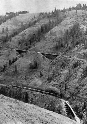
From Spaulding, in the depths of Clearwater Canyon, the railroad raises itself over a 3000 foot shelf onto the prairie of the Camas by means of a feat of engineering ingunity paralleled only by the machinations of the narrow-guage emperors in the Colorado Rockies. Showpiece of the line is Lapwai Canyon, a blind gorge some two and one-half miles in length and 1500 feet in depth. It was here in the 1800s that Chief Joseph and his Nez Perces indians made their last stand, vanquishing a retreating troop of United
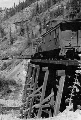
Camas Prairie Railroad belies its name more often than not. View of east wall of Lapwai Canyon clearly shows how tough the builders had it. Trestles alternate with cuts and tunnels to bridge the gullies and humps. Northern Pacific Extra 1506 coming upgrade with full tonage of empties slips her drivers from time to time. Heavier trains rated 2, 3, and 4 pushers. Photo about 1950, Phillip Hastings.
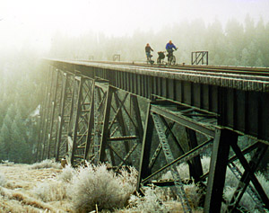
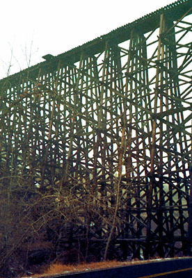
Eloy crossing Half Moon Trestle on our descent in Lapwai Canyon. Half Moon is the largest of the trestles in the canyon being 668 feet long and 147 feet high and containing one million board feet of lumber.
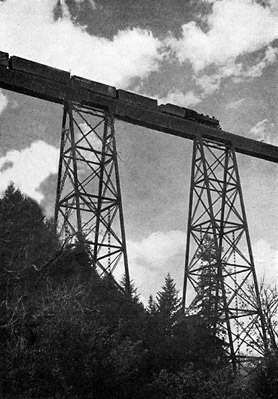
Canyon country operation calls for terraced railroading. Extra freight 1521 navigates S-trestle 20 minutes after crosing structures above it on the east wall of Lapwai Canyon.
States Cavalry before being routed out of their homeland in the name of white civilization. A few years later, unlike the hapless troops trapped in the blind canyon, a Northern Pacific engineer established a route for the railroad that turned and retraced its steps to the canyon mouth, climbing upward at a steady three percent along the canyon's east wall. At the apex of the gorge the track doubles back upon itself by means of a 900 foot horsehoe tunnel with a trestle at each end, on a semicircle of only 1000' diameter.
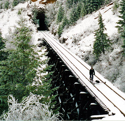
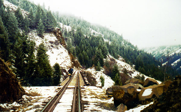
Descending along the east wall of Lapwai Canyon, Peter crosses one of the twenty-seven trestles in this five mile stretch of magnificent mountain railroading.
The ascent of the east wall is accomplished over a series of trestles, interrupted by deep cuts and tunnels, to compensate for the washboard-like vertical gashes carved in the canyon wall by centuries of erosion. In one section of five miles of track through the canyon there are seven tunnels and twenty-seven trestles. The largest of these timber crossings, the Half Moon trestle, is 668 feet long and 147 feet high and contains
over one million board feet of lumber.
Once the summit of the broad plateau from which the railroad takes its name is reached, the character of the line changes abruptly as it enters the broad vistas of wheat country. From Craigmont for the final 32 miles to Grangeville (the rails reached this terminus in 1891) the gently rolling tableland is lush with wheat, wild flowers and miniature evergreen forests. But even here there are many surprises, for whenever a
valley was encountered, the railroad just bridged across it, and many monsterous wooden trestles appear without the least bit of warning. The Camas Prairie Railroad was aptly referred to as "the railroad built on stilts."
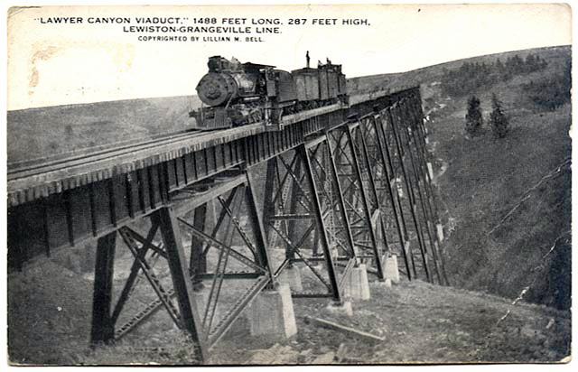
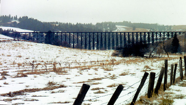
In the middle of this rolling tranquility Lawyers Creek harshly interrupts the pastorial pattern, cutting a gorge spanned by the only steel bridge on the line. Depending on your source of infomation, the bridge is 1400 feet long and 294 feet high. Regardless of a agrument of a few feet one way or the other, riding over it really gets the adrenalin flowing. It, like all the timber trestles on the line, is narrow and without guardrails and the drop to the canyon floor is truly frightening. The ties and rails were coverend with frost and frozen fog when we crossed, and doubts about the sanity of this adventure quickly clouded my mind, but I'm jumping ahead of my story.
Lawyers Creek Canyon, the only steel bridge on the line. Approximately
1400 feet long and
between 257 and 296 feet high, depending on your source of information. Any way you mesure it,
a thrill to ride across. Through some quirk of nature, this gorge ist he only thing of its kind in the immediate vicinity, being surrounded on all sides by gently rolling wheat-lands.
Above, an old post card showing a freight stopped on Layers Canyon Trestle for its portrait early in the 20th century. At left, at atmost the identical spot but looking from the opposite side, Dick and Eloy pose as Peter records the trios crossing through a low hanging freezing cloud in 2000. The Second Subdivision had ceased operations at this time pending salvage contracts. We did meet up with the foreman in his highrider and were told to get off the tracks. A real surprise for both parties. We complied as soon as we reached our vehicle which was ahead of us in the little town of Culdesac.
Dick, Eloy and I met in Lewiston and drove our two vehicles to the little burg of Culdesac where we left one and continued on over the pass to the picturesque town of Cottonwood, settling into a quaint motel for the night. We would be riding back (and mostly downgrade) to Culdesac the following day and would drive the vehicle left there back to Cottonwood for the second night.
The first night we hiked into town before turning in and tossed down a couple of hot buttered rums in the historic local saloon, the only establishment open after six pm. A little deadening of the senses was excusable
because Dick and Eloy lost the coin toss and had to share one of the two beds at the motel. At least one of us had a good nights sleep.
At first light we were up and out and on our way to Ferdinand where we left our second vehicle and put on the rails for Culdesac. There had been a heavy freezing for for about a week and we were concerned that we wouldn't be able to see anything. As it turned out, the fog cleared as we dropped into the canyon later in
the day, but that morning every tree, bush and blade of grass looked to be made of crystalized glass, a true winter wonderland. When we got to Lawyers Creek Trestle, the effect of the fog was awesome . You couldn't see the far end of the bridge, it just disappeared into space out over the canyon floor!
About three hours into our ride I chilled out, not from the bitter cold, but in apprehension as I saw the twin headlights of the railroads' highrider looming toward me out of the fog. Jumping off my bike I had it clear of the rails in about six seconds, but there was no place to hide. When the highrider pulled abreast of me and stopped, I could see the foreman was not pleased at this encounter. After suffering a good bawling out, I explained that we were told the line was no longer in use, to which he replied "These are still my rails, and I want you off". We were in the middle of the boonies with snow drifts as far as the eye could see, and there was really no "off" available. After some "yes sirs" and "no sirs" on my part, he cooled down a bit but then I had to tell him to watch out
Dick on his steel wheeled bike. Note the crystalized foliage in the background.
for two more riders down the line. I thought for sure this last admission would be our coup de grace but he said nothing more and drove on down the tracks. For the record we did comply, but it was not until later in the day when we reached our vehicle in Culdesac that we were able to remove ourselves.
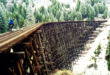
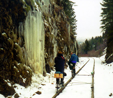
Our ride down into Lapwai Canyon was truly wonderful. Trestle after trestle clung to the side of the canyon wall, tunnels with frozen icicles 10 feet long guarded the entrances like ferocious dragons
teeth, the walls of the cuts were frozen solid with cascading banks of ice and the snow covered mountain vistas across the deep canyon below us were breathtaking. We stopped for lunch with a trestle on one side and the mouth of a tunnel on the other, looking at us hungrily as we ate. But surely after gobbling up steam locomotives we must have looked like puny morsels. Then we were off again, crossing Half Moon trestle and creeping through the blackness of horseshoe tunnel (dang those old batteries) reversing our direction and then rocketing down the rails toward Culdesac.
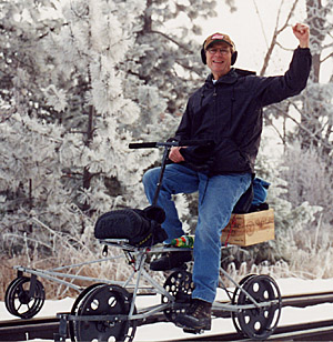
Eloy and I were riding bikes of similar design made by an aging hot rod and motocycle buff called Whitey who lived, to my great surprise, in Lewiston. Where my bike has only the rear wheel in place, Eloy's railbike frame has a pocket in which his front wheel rested, leaving him with the abilitiy to have his entire bike intact to ride on the street. This was one of Whitey's earlier designs and it's too bad he didn't contiune with this concept. Dick was riding his metal wheeled machine of Swedish design, which made a lot of rail noise but was a joy to ride. He let us both try it on the run into Culdesac and it made you feel like
Down into Lapwai Canyon the ride was truly wonderful. We crossed trestle after trestle with the bottom of the canyon far below and snow covered mountains spread out before us.
Frozen banks of icicles covered the walls of the cuts in a fairlyland of beauty.
the President of the Railroad. It rocked gently from side to side making it feel like a real piece of railroad equipment. All three bikes were capable of speeds of 15 MPH or more with complete safety, and we rode them flat-out to the end of the canyon. Eloy and I had some tough going on the high prairie when the snow between the rails reached our low outriggers forcing us to stand and peddle strenuously to plow ahead. All the bikes were equipped with makeshift "snowplows" which fortunately didn't come into use.
The Next morning we had planned to ride in the opposite direction from Cottonwood, out into the prairie towards Grangeville. But the weather was still very cold and heavy fog shrouded the countryside. Any ride that day would have been an anticlimax to our previous adventure, so we spent the morning visiting some remote prairie towns and exploring the backroads along the Snake River Canyon.
Hey, we're not as single minded as you might have thought.
Even on the rolling prairie, when a valley was encountered the railroad simply built a trestle, and dozens dot the countryside between Cottonwood and Craigmont.
What could be as awesome, and as thrilling to ride across.
By Peter with information from Phillip Hastings, Railroad Magazine
Phillip Hastings
Phillip Hastings